Lakes Entrance - Mississippi Creek Bridge

Share Lakes Entrance - Mississippi Creek Bridge on Facebook Share Lakes Entrance - Mississippi Creek Bridge on Twitter Share Lakes Entrance - Mississippi Creek Bridge on Linkedin Email Lakes Entrance - Mississippi Creek Bridge link

About the Project

Scriveners Road, Kalimna West has become a strategic alternative route to Lakes Entrance. It is acknowledged as being the detour utilised to access Lakes Entrance when the Princes Highway is closed. Scriveners Road also provides essential access for the management of part of the Colquhoun State Forest north of Lakes Entrance and crosses the Gippsland Lakes Discovery Trail.

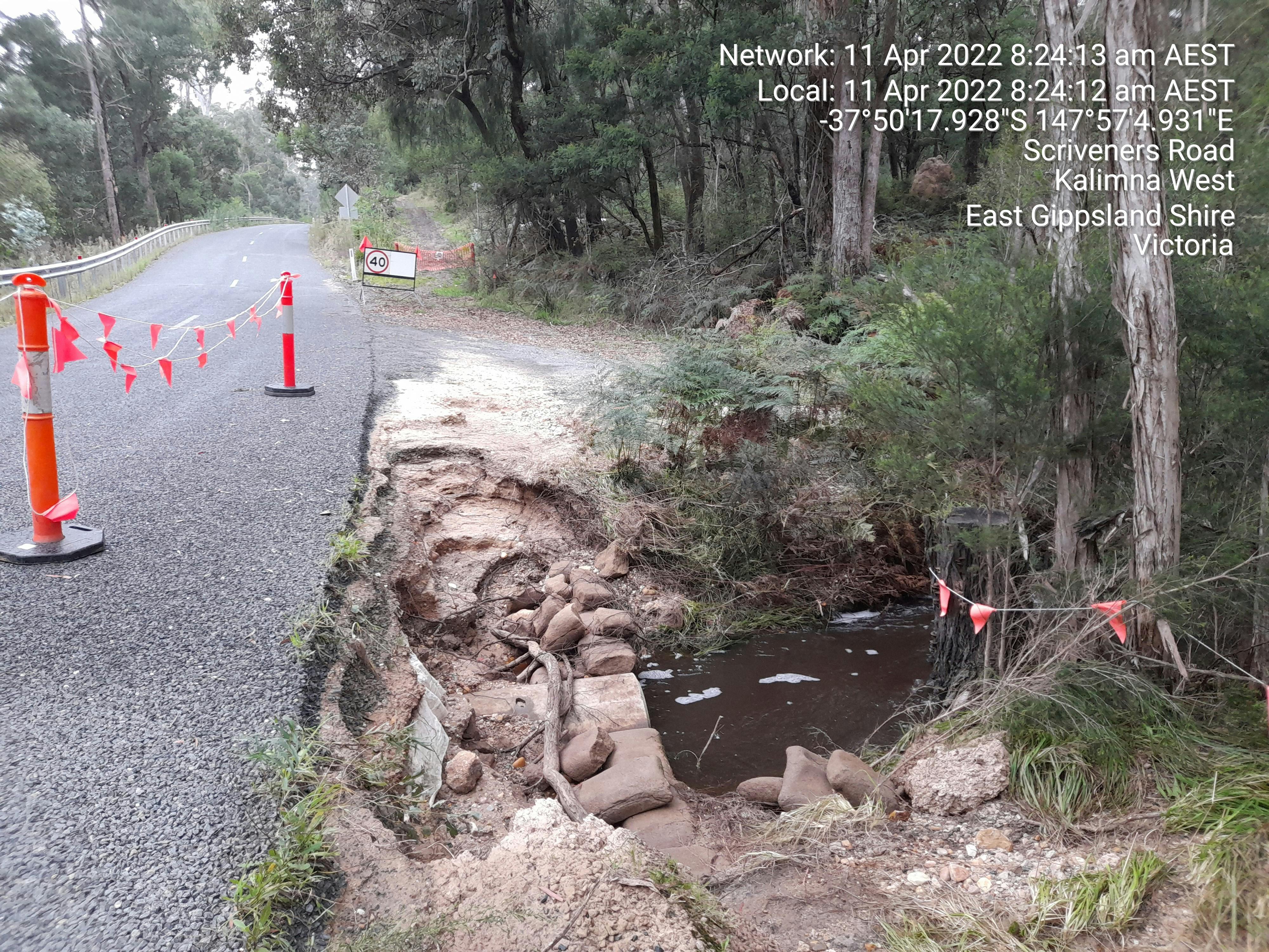
Council has upgraded the road over the years from a gravel track to a sealed road. In spite of this, the section over Mississippi Creek is still narrow and subject to regular flood damage.

The floodway was originally formed to mitigate the commanding flood flows, but the crossing has been heavily damaged by the many floods that have occurred since 2020. In 2022, the flood damage to the downstream side and the deteriorating condition of the upstream headwall had affected the road formation to the extent that it was no longer wide enough to cater for two-way traffic.

Council implemented single lane traffic whilst investigating and designing temporary works and were waiting for the compromised sewer main to be upgraded and relocated by East Gippsland Water. In 2023 the reinstatement of the road formation to its former width was achieved by using sheet piling as a temporary solution.

Objective and scope

The objective of the project is to upgrade the current culvert crossing to a higher bridge, thereby improving the road's functionality and resilience, particularly against floods. The project aims to ensure the new bridge has a 100-year design life and a load capacity of up to 68 tonnes. The project scope includes:

  • Geotechnical investigation: Assessing the soil and ground conditions to inform the bridge design and construction process.
  • Hydrological and hydraulic modeling: Analysing water flow patterns and hydraulic characteristics to ensure the bridge can withstand potential flooding events.
  • Liaison with stakeholders and authorities: Collaborating with relevant parties to ensure regulatory compliance and gather input from stakeholders.
  • Vegetation assessment and permits: Evaluating the impact of the project on surrounding vegetation and obtaining necessary permits for construction.
  • Cultural Heritage Management Plan: Developing a plan to protect and manage cultural heritage sites that may be affected by the project.
  • Detailed design: Creating a comprehensive design for the new bridge, taking into account flood resilience and potential realignment of road approaches to enhance safety.
  • Grant funding application for construction works: Seeking financial support for the implementation of the project.

Additionally, a consultant has been engaged to undertake the engineering survey, geotechnical investigation, and detailed engineering design. While flood resilience is the primary focus, the project will also consider opportunities to improve road safety by realigning road approaches.

Consultation and community engagement

This project was initiated following community feedback identifying concerns regarding access to Lakes Entrance when the Princes Highway is closed, and reports of ongoing flood damage to Council infrastructure.

Letters will be posted to local residents directly affected by the investigations and subsequent activities to inform them of the proposed project. Project updates will also be provided in the tab below; please subscribe to follow this project to receive important information regarding this project directly to your inbox.

Funding

East Gippsland Shire Council has provided funding to undertake investigations and design.

The commencement of construction is subject to future funding availability and the success of future funding applications.


We welcome your continued interest in this project; project updates will be provided on YourSay in the tab below, when available. Please click 'Subscribe' at the top of the page to follow this project and to receive important information directly to your inbox.

Should you wish to search for other projects near you, simply type the town name in the search bar.
  • 12 September 2024

    Share 12 September 2024 on Facebook Share 12 September 2024 on Twitter Share 12 September 2024 on Linkedin Email 12 September 2024 link

    The design consultant has developed a preliminary design for a proposed bridge and road safety upgrade around the creek.

    We have arranged for a consultant to undertake ecological assessment of the impacted area; flora and fauna species have been carefully identified and mapped.

    The design will now progress through iterations to avoid and minimise impact on native vegetation whilst achieving a suitable level of flood resilience.

  • 2 May 2024

    Share 2 May 2024 on Facebook Share 2 May 2024 on Twitter Share 2 May 2024 on Linkedin Email 2 May 2024 link

    Project Engineers are currently working to identify the best possible alignment for of the bridge and the road approach.

    A meeting was recently held on site with Forest Fire Management to discuss design options for suitable access to the Discovery Trail and to the waterpoint.


    We welcome your continued interest in this project. Please choose to follow this project on YourSay to receive important information regarding this project directly to your inbox.

Page last updated: 13 Sep 2024, 02:39 PM